
Score and compare apartments using real OpenStreetMap data.
Amenities, transit, green space, commute times, rent — all in one weighted score.
Quick Start · GUI · How It Works · Configuration · CLI Reference · Design Notes


FlatScorer is a Python tool — a command-line one, with an optional browser GUI over the same engine — that helps you objectively compare apartments (or any set of candidate addresses) by pulling spatial data from OpenStreetMap and computing a composite livability score.
You define your candidate flats, the places you care about getting to (office, university, train station, ...), and how much you value each criterion. The tool handles the rest — geocoding, network routing, amenity counting — and gives you a ranked table, a CSV, an interactive HTML map, and a sensitivity analysis that tells you whether your ranking is robust or hinges on a single weight choice.
Works anywhere in the world — CRS is auto-detected from your coordinates.
On a real shortlist, the ranking reproduces the author's own hand-ranking of the top 3 in roughly 9 cases out of 10 — a small, self-assessed sample, but it is the check the whole design exists to pass.
📐 Design notes — why the score is built the way it is, including a four-city measurement of whether the street-network download is necessary (ρ=0.986 without it) and a POI data source that was evaluated and rejected.
| Terminal output | Interactive map |
|---|---|
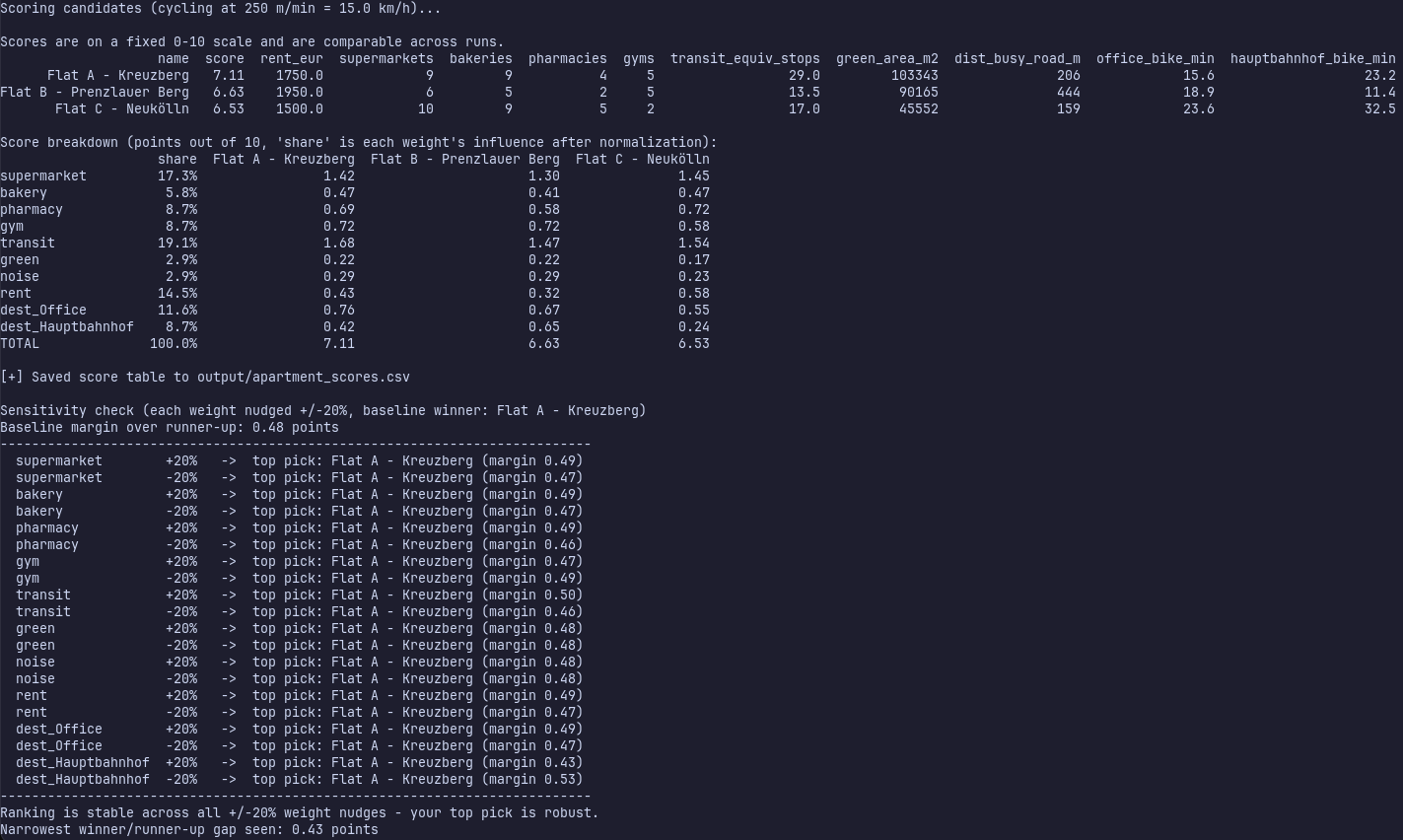 |
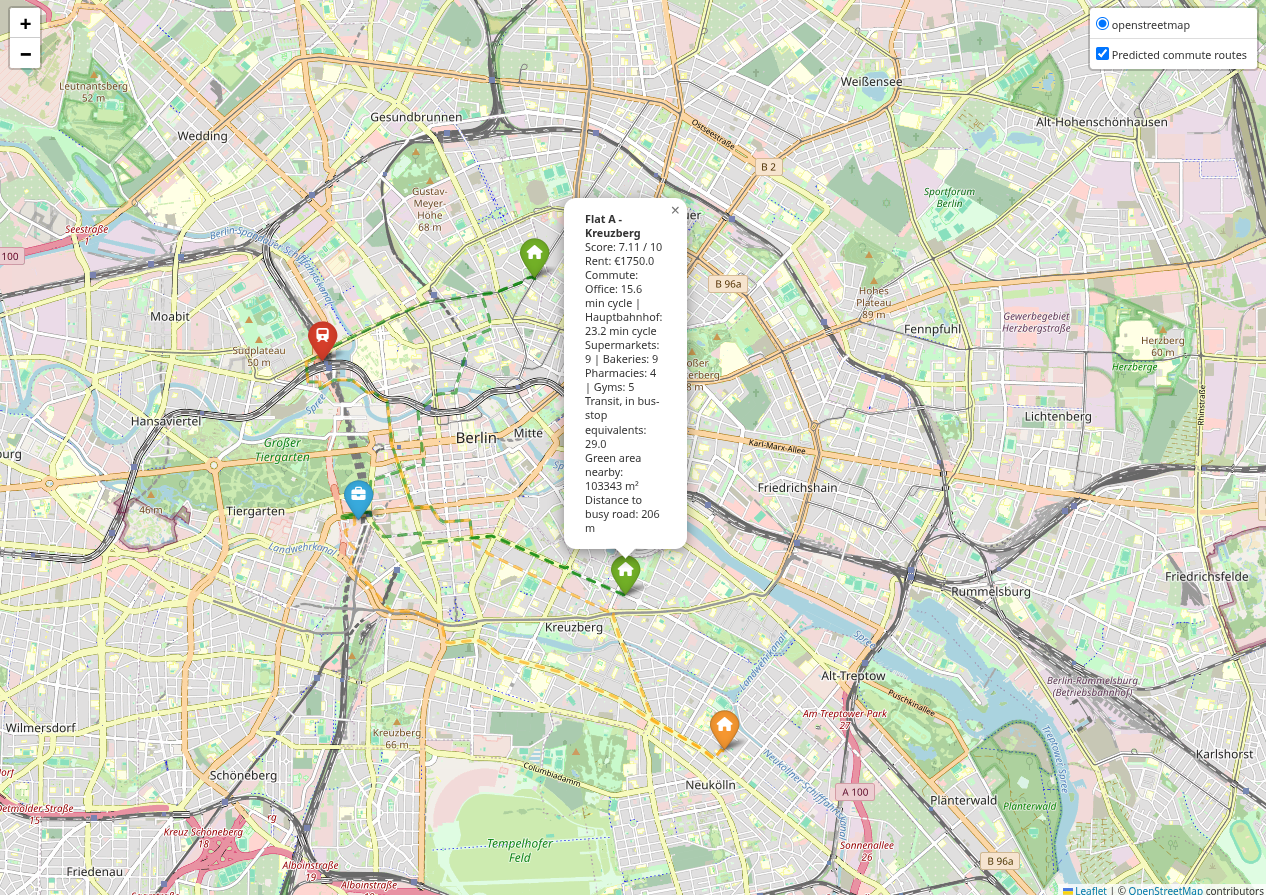 |
Install it as a command-line tool:
pip install flatscorer

# Generate a starter config with demo data
flatscorer --generate-config config.json

# Edit config.json with your own addresses, then run
flatscorer --config config.json
No Python toolchain? Run the GUI without installing anything, using
uv:
uvx --from "flatscorer[gui]" flatscorer-guipipx works too and keeps the fairly heavy geospatial
stack out of your global site-packages: pipx install "flatscorer[gui]".
Or work from a checkout:
git clone https://github.com/Aduneer/FlatScorer.git
cd FlatScorer
pip install -e .                      # editable — picks up your edits
flatscorer --generate-config config.json
flatscorer --config config.json
The code lives in src/flatscorer/, so a bare pip install -r requirements.txt
installs the dependencies but not the package itself and python -m flatscorer
won't resolve. Either install it as above, or point Python at the source tree for
a one-off: PYTHONPATH=src python -m flatscorer --config config.json.
Running without --config uses built-in demo data (three flats in central
Berlin) so you can try it immediately.
Prefer a form over JSON? There's a Streamlit interface that wraps the same scoring engine — build your candidate list and destinations in a table, tune weights with sliders, and get the ranked table and interactive map right in your browser.
# The GUI is an optional extra on the published package
pip install "flatscorer[gui]"
flatscorer-gui

# Or from a checkout
pip install -r requirements-gui.txt   # dependencies only
streamlit run src/flatscorer/gui/app.py
streamlit run works from a checkout without installing the package — app.py
puts src/ on sys.path when flatscorer isn't importable, because Streamlit
only adds the script's own directory.
flatscorer-gui forwards any extra arguments to streamlit run, so
flatscorer-gui --server.port 8600 does what you'd expect. To run it without
installing anything at all, see the uvx line in Quick Start.
It reuses the flatscorer engine directly, so results are identical to the CLI —
this is just a friendlier way to build the config and view the output.
A run takes a couple of minutes, most of it waiting on Nominatim's one-request- per-second geocoding and the OpenStreetMap downloads. The Run page shows a progress bar naming each step as it starts ("Downloading the cycling street network..."), so a slow run reads as slow rather than as a hang.
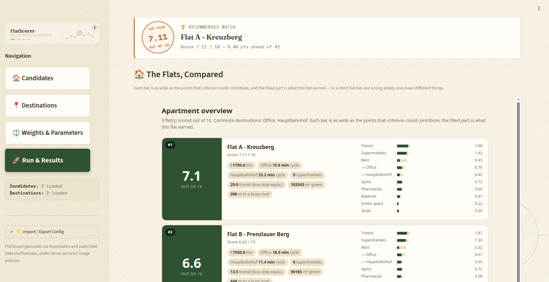
The demo config ships no flat photos, so each card shows the score dial that
stands in for one. Point a candidate's image at a URL or a local file to get a
photo panel there instead.
For each candidate apartment, FlatScorer:
- Geocodes all addresses via Nominatim (through OSMnx).
- Downloads a street network per travel mode your destinations actually use (pedestrian, cycling, or both) plus the points of interest for the bounding region, from the Overpass API (with automatic mirror failover).
- Deduplicates POIs mapped both as a node and as a building outline (see Duplicate POIs).
- Counts nearby amenities within a configurable radius (default 500 m): supermarkets, bakeries, pharmacies, gyms, and transit stops (see Transit stops are weighted).
- Measures green space — park and forest polygon area plus point features.
- Estimates noise exposure via distance to the nearest primary/secondary road.
- Routes commutes to each of your defined destinations over the real network for that destination's travel mode — walking (~5 km/h) or cycling (~15 km/h), see Travel modes.
- Normalizes every metric onto a common 0–1 scale.
- Computes a weighted average of those normalized values, on a 0–10 scale.
A destination declares how you get there with "mode": "walk" (the default) or
"mode": "bike". It changes the answer substantially: a 35-minute walk is often
a 12-minute cycle, and which flats look good depends on which of those you meant.
Each mode routes over its own street network, downloaded separately. That is deliberate and not negotiable: the pedestrian graph carries footways a bike may not use and drops roads it may, so a cycling time computed on it would be wrong in both directions at once — and wrong invisibly, since it still produces a plausible number.
The networks are downloaded lazily, one per mode your destinations actually mention. A single-mode config makes exactly one download — that covers every config written before this existed, which walked everywhere, and the shipped demo, which cycles to both of its destinations. Only a genuinely mixed config pays for a second.
Each mode has its own pace (walking_speed_m_per_min, cycling_speed_m_per_min)
and its own column in the results: office_bike_min beside supermarket_walk_min,
so a cycled commute is never reported under a heading that says "walk". On the map,
cycled legs are drawn dashed.
A metro station and a once-hourly bus stop are not the same thing, so they don't count the same. Each stop contributes bus-stop equivalents:
| Stop | OSM tag | Worth |
|---|---|---|
| Rail / metro station | railway=station |
3.0 |
| Rail halt | railway=halt |
2.0 |
| Tram stop | railway=tram_stop |
1.5 |
| Bus stop | highway=bus_stop |
1.0 |
A bus stop stays at 1.0 deliberately: saturation.transit keeps meaning exactly
what it did before, so the change only moves scores where the transit genuinely
is better rather than inflating everyone's.
These are a judgement about service level, not a preference — how much transit
matters to you is already weights.transit, and a second knob on the same axis
would just be a way to count the same opinion twice.
A stop mapped as both (one pole tagged highway=bus_stop and
railway=tram_stop, which is how interchanges are usually drawn) earns both, at
2.5 — it really does give you both services.
The CSV column is transit_equiv_stops, and the run log prints the mix it found.
OpenStreetMap frequently maps one real place twice — a supermarket tagged on a POI node and on the building outline around it. Overpass returns both, so a naive count sees two supermarkets where a shopper sees one.
This matters more than it sounds. The duplication isn't uniform: it's most common where mapping is most thorough, which tends to be central, dense, well-surveyed neighbourhoods. Left alone it hands those areas an amenity bonus they haven't earned — inflating exactly the places that were already scoring well, which is the wrong direction for a comparison tool.
FlatScorer merges a node and an area into one feature when the area's geometry
comes within poi_dedupe_tolerance_m of the node and their name tags don't
disagree (an unnamed building still merges with a named node, which is the usual
shape of the duplicate). For amenity counts the node survives; for green space
the polygon survives, because it carries the m² the green score is made of.
Two nodes are never merged with each other. Bus stops legitimately come in pairs a few meters apart on opposite sides of a road, and collapsing those would be the same inflation bug pointing the other way.
Every merge is reported in the run log, so the numbers behind a score stay auditable.
Every metric is first mapped onto 0–1, then combined as a weighted average and rescaled to 0–10:
score = 10 × Σ (wᵢ × normalizedᵢ) / Σ wᵢ
| Term | Normalized as | Anchor (configurable) |
|---|---|---|
| supermarket, bakery, pharmacy, gym | count / (count + half) — saturating |
saturation.<metric> |
| transit | same curve, over weighted stops rather than a headcount | saturation.transit |
| green | same curve over green_score (m² / 1000 + 0.5 per point feature) |
saturation.green |
| noise | min(distance, cap) / cap |
noise_cap_m |
| rent | 1 − rent / budget, clamped to 0 |
rent_budget_eur |
| each destination | 1 − minutes / cap, clamped to 0 |
commute_cap_min |
The 0–10 scale is real. Every term is bounded and the weights are normalized to sum to 1, so no input can push a score outside 0–10 — and because the anchors are absolute constants rather than the candidate set's own min and max, a score means the same thing in every run. Two runs a month apart are comparable.
Three consequences worth knowing:
- Only the relative sizes of weights matter. Doubling every slider changes nothing. A weight's real meaning is its share of the total, which is the most points out of 10 that term can contribute — the GUI's Weights page shows this share for every factor, destinations included.
- Destination weights compete in the same pool as the amenity weights, rather than being points-per-minute penalties.
- Amenities have diminishing returns. With
saturation.supermarket: 2, the first supermarket within the radius is worth far more than the sixth. This is deliberate: a raw count let a well-mapped district out-score everything else on supermarkets alone.
The sensitivity report prints the gap between the top two; under 0.25 points they are reported as effectively tied. Map pins are coloured by absolute score (green above 6.6, orange above 3.3, red below), so a pin colour also means the same thing in every run — and a field of similar flats is allowed to look similar.
Migrating from a pre-normalization config: scores from older versions are not comparable to these.
euros_per_extra_minuteis gone (rent is no longer converted to commute-minutes); setrent_budget_eurto the most you would pay instead. Old configs still load — the removed key is simply ignored and the new anchors fall back to their defaults.
Results are written into output/ beside wherever you ran the tool, which is
created if it doesn't exist. Point output.csv_file / output.html_file
somewhere else if you'd rather — a path into a directory that doesn't exist yet
works, it gets created too.
The OpenStreetMap download cache is separate and lives in your user cache
directory (~/.cache/FlatScorer on Linux, ~/Library/Caches/FlatScorer on
macOS, %LOCALAPPDATA%\FlatScorer\Cache on Windows). A downloaded street network
is expensive and identical wherever you ask for it, so it's shared across runs
instead of being rebuilt per working directory.
| Artifact | Description |
|---|---|
| Terminal table | Ranked summary printed to stdout |
output/apartment_scores.csv |
Full metrics for every candidate. The first line is an OpenStreetMap credit comment — read it with pd.read_csv(path, comment="#") |
output/apartment_map.html |
Interactive Folium map with color-coded pins and predicted commute routes |
output/apartment_overview.html |
One card per flat showing what each criterion contributed to its score — self-contained, opens offline, sendable |
| Sensitivity report | ±20% weight perturbation check on ranking stability |
Everything is driven by a single JSON file. Generate a template with
--generate-config, then edit it.
{
  // Apartments to compare
  "candidates": [
    {
      "name": "Flat A - Kreuzberg",
      "address": "Oranienstraße 1, 10999 Berlin, Germany",
      "rent": 1200,
      // Optional. Never scored — carried into the CSV and the map popup so you
      // can click from a result straight back to the listing. Omit it entirely
      // if you have no link; must be http:// or https:// if you do.
      "url": "https://www.example-listings.de/expose/12345",
      // Optional. Never scored — shown on this flat's card in the overview
      // report, which falls back to a score dial when there is no photo.
      // Either an image URL or a path to a file on this computer; a local file
      // is embedded into the report so it stays one sendable file, as long as
      // it is under 2 MB and is a .jpg/.jpeg/.png/.gif/.webp. Anything that
      // can't be read is logged and falls back to the dial.
      // Photos you point this at stay yours to account for: listing photos are
      // usually the agency's copyright, and embedding one copies it into the
      // report — so treat a report containing them as a private document.
      "image": "https://www.example-listings.de/photos/12345.jpg"
    }
  ],

  // Places you commute to — each gets a travel-time column
  "destinations": {
    "Office": {
      "address": "Alexanderplatz 1, 10178 Berlin, Germany",
      "weight": 0.20,        // importance, relative to the weights below
      "mode": "bike",        // "walk" (default) or "bike" — see Travel modes
      "icon": "briefcase",   // FontAwesome icon on the map
      "color": "blue"
    }
  },

  // How much each factor matters, relative to the others. Only the ratios
  // count — these are normalized to sum to 100% before scoring.
  "weights": {
    "supermarket": 0.30,
    "bakery":      0.10,
    "pharmacy":    0.15,
    "gym":         0.15,
    "transit":     0.33,
    "green":       0.05,
    "noise":       0.05,
    "rent":        0.25
  },

  "parameters": {
    "buffer_m": 500,               // amenity search radius in meters
    "noise_cap_m": 200,            // quiet term maxes out at this distance from a busy road
    "rent_budget_eur": 2500,       // rent at/above this scores 0 on the rent term
    "commute_cap_min": 45,         // a commute this long scores 0 for that destination
    "walking_speed_m_per_min": 83.33,  // assumed pace; 83.33 m/min = 5 km/h
    "cycling_speed_m_per_min": 250,    // assumed pace; 250 m/min = 15 km/h
    "poi_dedupe_tolerance_m": 10,  // how close a node and a building outline merge
    "max_bbox_span_km": 30,        // refuse to download an area wider than this
    "saturation": {                // count earning half credit (diminishing returns)
      "supermarket": 2, "bakery": 2, "pharmacy": 1,
      "gym": 1, "transit": 4, "green": 30   // transit counts bus-stop equivalents
    },
    "projected_crs": "auto",       // auto-detect UTM zone, or e.g. "EPSG:25832"
    "show_walk_routes": true,      // draw predicted commute routes on the map by default
    "routing_mode": "network",     // "network" routes over real streets; "straight_line" estimates
    "detour_factor": 1.25,         // straight_line only: how much longer a real route is
    "nominatim_url": "https://nominatim.openstreetmap.org/"  // geocoding service
  },

  "output": {
    "csv_file": "output/apartment_scores.csv",
    "html_file": "output/apartment_map.html",
    "overview_file": "output/apartment_overview.html"
  }
}-
rent_budget_eur— The rent you consider unaffordable. Rent at or above it scores 0 on the rent term, free rent scores 1, and everything in between is linear. Set it to the top of your budget; setting it far above your actual range flattens the differences between candidates. -
commute_cap_min— The travel time at which a destination stops earning anything. Same shape as the rent term, including the same tradeoff: everything past the cap scores 0, so a 50-minute commute and a 90-minute commute are indistinguishable on that term. One cap covers every mode — it is how long you are willing to travel, not how far. If the score breakdown shows a destination at 0.00 for every candidate, raise the cap, switch that destination tobike, or accept that nobody is getting there. Both anchors are deliberately absolute — that is what makes a score mean the same thing between runs. -
walking_speed_m_per_min/cycling_speed_m_per_min— The pace each mode's routed distances are divided by to get minutes. The walking default 83.33 m/min is 5 km/h, the usual planning figure for an unhurried adult on the flat; 100 m/min (6 km/h) is a brisk walker. The cycling default 250 m/min is 15 km/h, urban cycling including junctions, lights and locking up — not the speed a fit rider holds on a clear path, which is why it is well under what a bike computer reports. Both only mean anything alongsidecommute_cap_min, because they multiply out: a slower pace makes every commute longer in minutes and so pushes more destinations towards the cap. If you change one, sanity-check the other — the routed distances themselves have not moved. -
saturation— The count that earns half credit for each amenity, i.e. how quickly more of something stops helping. Lower is easier to satisfy: atsupermarket: 1, a single supermarket already earns half the term. -
poi_dedupe_tolerance_m— How close a POI node and a building outline have to be before they're treated as one real-world place mapped twice (see Duplicate POIs above). Distance is measured to the building's geometry rather than its centroid, so a node anywhere inside the building already counts as 0 m and this only has to absorb nodes placed just outside a wall. Raise it and genuinely distinct neighbouring shops start merging; 0 merges only nodes that fall exactly on the outline. -
max_bbox_span_km— A sanity check on how far apart your addresses are, not a scoring anchor. Everything you list has to fit inside a box this wide, or the run stops before the OpenStreetMap download with a message naming the address that is furthest from your candidates. It exists because the usual cause of a huge search area is a typo: an address that geocoded to the wrong city produces a box hundreds of km across, and asking Overpass for that much pedestrian network is a several-minute hang ending in a rejection. 30 km covers any single-city search; raise it if you are genuinely comparing flats across a region. -
projected_crs— Coordinate reference system for metric distance calculations."auto"picks the correct UTM zone for your region. Override with an EPSG code if you have a preference. -
Destination
weight— How much this commute matters relative to every other factor. It competes in the same pool as the amenity weights, so a destination at 0.15 against weights totalling 1.5 controls 10% of the score — at most 1 point out of 10, earned by living next door to it. -
Destination
mode—"walk"(the default) or"bike", deciding which street network this commute is routed over and which pace it is divided by. See Travel modes; omitting it walks, so every config written before cycling existed scores exactly as it did. -
show_walk_routes— Whether the map's predicted-routes layer starts visible. The routes trace each candidate's actual shortest path to every destination over that destination's own network (color-matched to the candidate's score, dashed for cycled legs) and can always be toggled via the map's layer control regardless of this setting. Has no effect under"routing_mode": "straight_line", which measures no routes to draw. -
routing_mode— How commutes are measured."network"(the default) downloads the street network and routes over it, which is exact and is by far the slowest step of a run."straight_line"estimates each commute from straight-line distance instead and skips that download entirely, turning a multi-minute run into a few seconds.The approximation was measured before it was offered. Across three cities chosen for their barriers — Budapest across the Danube, Berlin across the Spree, Lisbon across its hills, 18 candidates each — the top pick never changed, and the ranking held at every commute weight tried. Roughly 4% of candidate pairs swapped, never by more than two places. The reason it works is that a detour factor is close to constant within a city, and a constant multiplier cannot reorder a ranking.
What you give up is the minutes themselves: they carry a few percent of error (mean ~5%, worst case ~19% in testing). Every surface that shows an estimated commute labels it
approx., and the CSV column is named..._min_approxso the caveat survives into a file you send to someone else.Good for tuning weights, comparing shortlists quickly, or running without waiting. Use
"network"when you want the commute figure itself to be right. -
nominatim_url— The geocoding service that turns addresses into coordinates. Defaults to the public OpenStreetMap instance; point it at your own Nominatim if you run one. It is configurable because Nominatim's usage policy requires that an application be able to switch service without shipping a new version — so the endpoint cannot be hard-coded. FlatScorer also throttles itself to the policy's 1 request per second and identifies itself by name in theUser-Agent. -
detour_factor— Used only by"straight_line": how much longer a real route is than the straight line between its endpoints. It does not affect the ranking — a constant cannot reorder anything — so it only decides whether the displayed minutes are honest and which candidates fall pastcommute_cap_min.Street layout drives this more than city size does. Measured medians: Washington DC 1.11 (a grid), Berlin 1.215, Lisbon 1.242, Budapest 1.347 (organic centres). The default 1.25 is the median of those. If your commute figures look consistently long or short against a route you know, this is the dial — a grid city wants ~1.1, a medieval core ~1.35. Setting it too high is worse than too low, because it pushes candidates past the commute cap that had not really reached it.
Both the CLI and the GUI check the whole config up front — before any geocoding or OpenStreetMap download — and report every problem at once, naming the candidate rather than just the field:
$ flatscorer --config config.json
Error: configuration is not valid (2 problem(s)):
  - candidates[0] ('Flat A'): 'rent' is missing - a flat with no rent would score
    as if it were free, taking full credit on the rent term and likely topping
    the ranking
  - destinations['Work']: 'address' is missing or empty
Rent is the one worth calling out. Because the rent term gives full credit at €0
and none at rent_budget_eur, a candidate with a blank, zero, or negative rent
doesn't score neutrally — it scores perfectly on that term and tends to win.
So a missing or non-positive rent is rejected rather than guessed at. The other
checks cover missing names and addresses, duplicate candidate names (they'd
silently overwrite each other), non-numeric or negative weights, an all-zero
weight vector, non-positive normalization anchors, an unrecognised destination
travel mode, and a candidate url that isn't http:// or https:// — that
one is a scheme check rather than fussiness, since the link is rendered as a
clickable href in the map popup and config files get passed around.
In the GUI the same problems appear on the Run page and the run button stays disabled until they're fixed.
usage: flatscorer [-h] [-c CONFIG] [--generate-config GENERATE_CONFIG]
                  [--csv CSV] [--html HTML] [--check-config] [-q] [--version]

FlatScorer - Multi-Criteria Apartment Scoring Engine

options:
  -h, --help            show this help message and exit
  -c, --config CONFIG   Path to JSON configuration file
  --generate-config GENERATE_CONFIG
                        Write default example config JSON to specified file
                        and exit
  --csv CSV             Override output CSV file path
  --html HTML           Override output HTML map file path
  --check-config        Validate the configuration and exit, without using the
                        network
  -q, --quiet           Suppress detailed logs
  --version             show program's version number and exit
python -m flatscorer takes the same arguments, for when the console script
isn't on your PATH.
--check-config runs the whole validation pass and stops there, touching
neither Nominatim nor Overpass:
$ flatscorer --config config.json --check-config
[+] 'config.json' is valid: 3 candidate(s), 2 destination(s). No network requests were made.
A scoring run takes minutes and spends other people's bandwidth, so finding a
typo that way is a bad trade — this turns the edit-and-check loop into something
instant and free. It exits non-zero with the same messages a real run would
print, which is what makes it usable in a pre-commit hook or CI. With no
--config it checks the built-in demo.
- Python 3.9+
- Dependencies:
osmnx,networkx,geopandas,pandas,folium,shapely,requests,platformdirs, plusscipyandscikit-learn— osmnx treats those last two as optional, but nearest-node lookup needs them, so routing fails mid-run without them
Install everything with:
pip install flatscorer       # from PyPI
pip install -e .             # or from a checkout — dependencies and the package itself
pip install -r requirements.txt installs only the dependencies, not the
package, so it isn't enough to run the tool from a checkout on its own — CI
pairs it with pip install --no-deps -e ..
The Overpass API (used for OSM data) can be flaky. FlatScorer automatically retries failed requests and rotates through three public mirrors:
overpass-api.deoverpass.kumi.systemsoverpass.private.coffee
If all mirrors fail, check your internet connection or try again later — the OSM infrastructure occasionally has outages.
One response is not retried and does not fall through to the next mirror: a
429 Too Many Requests. That is not an outage, it is the server asking this
client to stop, so the run stops with a message telling you how long to wait.
Retrying it, or putting the same query to a different mirror, is how a temporary
throttle becomes a ban — and since FlatScorer identifies itself by name in its
User-Agent, a ban would land on the project rather than on one anonymous IP.
Anything already downloaded is cached, so a later run resumes from there.
Geocoding goes through Nominatim, which allows one request per second and has no mirrors. FlatScorer paces its geocoding calls to stay inside that limit and retries transient failures up to three times; an address Nominatim simply cannot match is reported immediately rather than retried, and the affected candidate is listed explicitly as missing from the ranking.
pip install -e ".[dev]"     # or: pip install -r requirements-dev.txt
pytest          # offline test suite — no Overpass, no Nominatim
ruff check .
Packaging metadata lives in pyproject.toml, which also holds the ruff and
pytest config. The runtime dependency list is read from requirements.txt so
there's exactly one source of truth; the gui and dev extras are declared
inline and mirror requirements-gui.txt / requirements-dev.txt, which stay
because CI installs from them. The code lives in src/flatscorer/, a src
layout, so nothing is importable without being installed and the tests exercise
the same package a user gets. pytest finds it via
[tool.pytest.ini_options] pythonpath.
| Module | Owns |
|---|---|
config |
DEFAULT_CONFIG and validate_config |
geocode, osm |
Nominatim and Overpass — the only network access |
spatial, routing |
Projection, the search-area guard, per-mode routing |
scoring |
Normalization, weighting, the score breakdown |
mapping |
The Folium map |
scorer |
FlatScorer, which drives all of the above in order |
cli, launcher |
The flatscorer and flatscorer-gui entry points |
paths |
Every runtime path, in one place |
gui/ |
The Streamlit front end — app.py plus views/, one module per nav page |
Each leaf module owns the DEFAULT_* constants for its own concern and
config imports downward from them, so the layering stays acyclic. flatscorer
re-exports the public names lazily (PEP 562), which keeps import flatscorer
from dragging in osmnx, geopandas and folium.
Two rules apply to gui/ specifically. Everything there uses absolute
imports, because streamlit run takes a path and Streamlit execs app.py
with no package context — a relative import raises ImportError at runtime. And
the view modules live in views/, never pages/: a pages/ directory beside
the entrypoint triggers Streamlit's multipage convention, which renders a second
navigation menu on top of the app's own.
Test modules mirror the source modules — test_config, test_scoring,
test_spatial, test_osm, test_routing, test_geocode, test_mapping,
test_cli, test_run — plus test_gui for the Streamlit front end via streamlit.testing
and test_api for the package-layout invariants (the lazy re-export table
resolving, import flatscorer staying free of the geo stack, the two gui/
rules above). Shared fixtures live in tests/conftest.py. Both pytest and
ruff check gate CI.
A package CI job builds the wheel and installs it into a clean venv with no
checkout on sys.path, so a module missing from packages or a broken console
script fails in CI rather than for whoever runs pip install first.
Releases go out from .github/workflows/release.yml, triggered by pushing a
vX.Y.Z tag. A PyPI version can never be re-uploaded or reused, so every check
runs before the upload: the tag has to agree with version in
pyproject.toml, and a wheel is rebuilt from the sdist and installed clean to
prove the sdist stands on its own ([tool.setuptools.dynamic] reads
requirements.txt at build time, so an sdist missing that file builds here and
is broken forever on PyPI). Running the workflow manually publishes to TestPyPI
instead, which is the rehearsal path that leaves the real version unburned.
requirements.txt declares version ranges, so CI installing the newest of each
would never exercise the declared floors — and a wrong floor then only breaks for
whoever happens to resolve to it. The min-versions CI job installs
requirements-min.txt (every >= pinned to ==) on the oldest supported Python
and runs the import, config-generation, and routing checks against it. Move a
floor in requirements.txt and you must move it there too.
FlatScorer runs on free, community-maintained OpenStreetMap infrastructure:
- Map, amenity, and road data: © OpenStreetMap contributors, ODbL.
- Geocoding via Nominatim, subject to its usage policy (max 1 request/sec, no bulk geocoding). FlatScorer's per-run usage stays well within this, but don't script it into a batch job over hundreds of addresses.
- POI and network data via the Overpass API, through the public mirrors listed below, each with their own fair-use rules. Be a good citizen — keep bounding boxes to what you actually need.
MIT — see LICENSE.