Locality
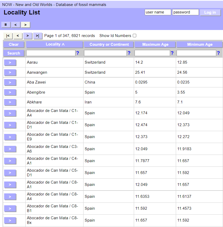
You can filter the list by entering search terms:
- use % for wildcard in text fields
- for numerical search terms use entries like: 10, <10, >10, <=10, >=10, 10...20, 0.3...0.4
- for country or continent, use the name or a comma-separated list of country or continent or both names. Use % for wildcard.
- > Examples: china,europe / af / %ara.
You can select a specific Locality to view by clicking the Go to record  button next to the Locality name. This will take you to the Locality details page.
Details of the selected locality are displayed in the right window. The total number of records displayed (found set) are those found by the search performed in the list.
The top of the record displays the Locality ID, the locality name and the country. Below are the latitude and longitude in degrees, minutes and seconds, and the locality's age.
The Locality has the following tabs: Age, Locality, Species, Lithology, Taphonomy, Climate, Ecometrics, Archaeology, Museums, Projects, and Updates.
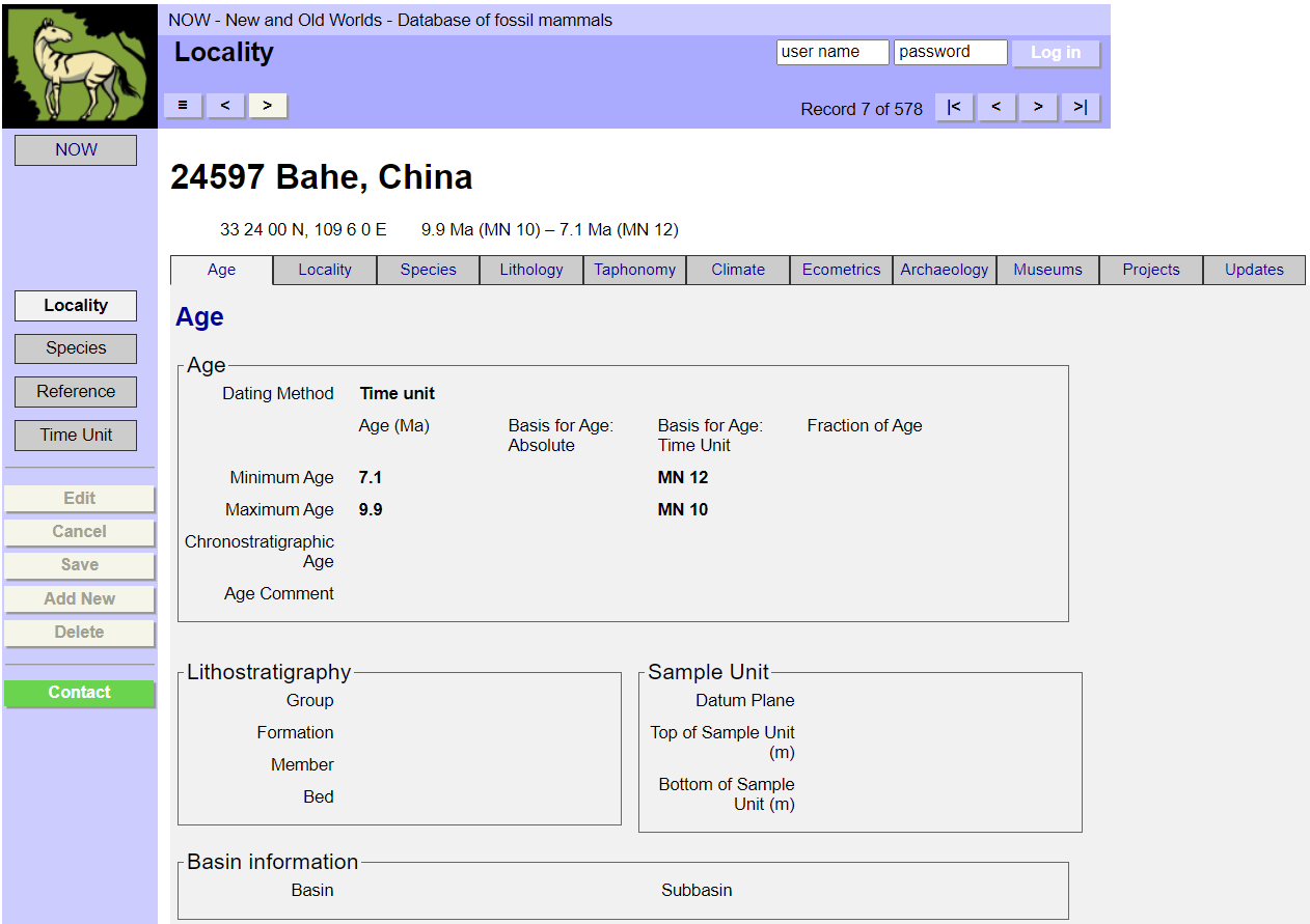
Locality name, country, coordinates, and age are minimum requirements when entering a new locality into NOW.
The Age tab contains information on Age, Lithostratigraphy, Sample Unit, and Basin information.
In order to provide the proper checks for internal consistency, the data-entry program must know what the basic method(s) were that the researcher used to assign the dates to the locality.
Allowed values:
- absolute2 / absolute
- composite3 / composite
- timeunit4 / time_unit
The specific basis for an age assignment.
Allowed values (Basis for Age: Absolute):
- AAR / >AAR
- Ar/Ar / >Ar/Ar
- C14 / >C14
- chemical / >Chemical
- Delta_O18 / >Delta O18
- ESR / >ESR
- fission_track / >Fission track
- K/Ar / >K/Ar
- obsidian_hyd / >Obsidian_hyd
- other_absolute / >Other absolute
- other_radiometric / >Other radiometric
- Rb/Sr / >Rb/Sr
- Sr/Sr / >Sr/Sr
- TL / >TL
- tree_ring / >Tree ring
- U-series / >U-series
- U/Th / >U/Th
Allowed values (Basis for Age: Time Unit):
- Select Time Unit from the pop-up windows. (Please make sure your browser has enabled pop-ups)
Allowed values (Basis for Age: Composite):
- Select a combination of Absolute and Time Unit ages.
When a (non-absolute) time unit is specified in either of the Basis for Age fields, it may be useful to specify only a fraction of the time represented by the time unit as the age range of the locality. In this way, for example, one can specify "Late Maestrichtian," "Middle Triassic," and so forth. However, this field can also be used more flexibly, to divide any time unit into up to 9999 segments and refer to anyone individually.
Allowed values:
- 1:2 / >Early half 1:2
- 2:2 / >Late half 2:2
- 1:3 / >Early third 1:3
- 2:3 / >Middle third 2:3
- 3:3 / >Late third 3:3
- other / Enter the fraction of age into the pop-up
The minimum (= youngest) age that the locality is thought to possess, in millions of years before the present (Ma). Absolute ages are usually expressed as a value +/- an error term; use (value - error term) for Minimum Age. The computer supplies numerical ages automatically for non-absolute ages (see Locality Ages in the Overview; Basis for Age, Fraction of Age, Maximum Age). It is legal for the Minimum Age to be equal to the Maximum Age, but this implies that the age of the locality is known exactly.
The maximum (= oldest) age that the locality is thought to possess, in millions of years before the present (Ma). Absolute ages are usually expressed as a value +/- an error term; use (value + error-term) for Maximum Age. The computer supplies numerical ages automatically for non-absolute ages (see Locality Ages in the Overview; Basis for Age, Fraction of Age, Minimum Age). It is legal for the Maximum Age to be equal to the Minimum Age, but this implies that the age of the locality is known exactly.
A chronostratigraphic unit, chron, biozone, biostratigraphic unit, etc., to which the locality can be assigned. This term may be identical to a time-unit Bfa field entry, but this field is independent of any of the age fields. Thus, one may record here a time-unit assignment (such as a Land Mammal Age) for a locality that is actually dated using radiometric dates, a floral or faunal affiliation, or an important chronostratigraphic or biostratigraphic correlate that is reflected in neither the age information or the stratigraphic information.
A field for a comment on the age assignment of the locality, including information relevant to the Dating Method, Bfa, Frac, and Chronostratigraphic Age fields.
The name of the stratigraphic group in which the locality is found. Group, as used here, is the highest of the hierarchical stratigraphic terms: group, formation, member, bed. It should be used flexibly to include appropriate designations for the locality. For example "Newark Supergroup" belongs here, though technically of a higher hierarchical level, because it is more informative than the less well-known corresponding group names.
The name of the stratigraphic formation in which the locality is found. "Formation" is the second in the series of hierarchical stratigraphic terms employed here: Group, Formation, Member, Bed. Do not include the word "Formation" as part of the name.
The name of the member of a formation in which the locality is found. "Member" is the third in the series of hierarchical stratigraphic terms employed here: Group, Formation, Member, Bed. Do not include the word "Member" as part of the name.
In the description of the stratigraphic data for the locality, the stratigraphy name of the bed in which the fossils are found. This is the lowest category in the sequence Group, Formation, Member, Bed. As in the case of the others, the term can be interpreted broadly, in order to accommodate designations for lowest-order local stratigraphic units, whether they are formally designated "beds" or not.
Some localities can be placed in measured sections, their position being expressed as a certain number of meters from a particular datum plane. This field is to contain a short description of that datum plane, in order to interpret the values in the Top of Sample and Bottom of Sample fields.
The distance, in meters, from the Datum Plane to the Top of the fossil sample unit. It may be positive (up) or negative (down) from the datum plane. It is assumed that the fossil deposit will exhibit some thickness; thus this field in concert with the Bottom of Sample Unit field can indicate the thickness of the unit. The Top of Sample Unit may equal the Bottom of Sample Unit if the thickness is negligible in relation to the section, or is unknown or otherwise not recorded.
The distance, in meters, from the Datum Plane to the bottom of the fossil sample unit. It may be positive (up) or negative (down) from the datum plane. It is assumed that the fossil deposit will exhibit some thickness; thus this field in concert with the Top of Sample Unit field can indicate the thickness of the unit. The Bottom of Sample Unit may equal the Top of Sample Unit if the thickness is negligible in relation to the whole section, or is unknown or otherwise not recorded.
The Locality tab contains information on Name, Latitude & Longitude, Locality, Synonyms, and Status.
The name of a locality and known synonyms. This may be a string of any letters or numbers, not exceeding 30 characters in length. (Abbreviate if necessary.) The database actually keeps track of each locality by its unique ID number (LID) which the computer assigns upon the initial entry of a locality to the database. Thus, there is no requirement for locality names to be unique. Their only function is as useful information. If the locality goes by more than one name in the literature or museum collections, try to choose the most well-known or distinctive designation for it, and include the other name(s) in the Synonyms List for the locality.
Latitude and longitude can be given either in degrees, minutes and seconds (dms) or in degrees with decimals (dec). The user interface fills automatically corresponding dms or dec fields and its therefore not necessary to know the coordinates in both of the coordinate systems.
Latitude and longitude can be given either in degrees, minutes and seconds (dms) or in degrees with decimals (dec). The user interface fills automatically corresponding dms or dec fields and its therefore not necessary to know the coordinates in both of the coordinate systems.
Yes/No
The present-day altitude in meters.
Allowed values:
- Currently set between -500 m to 9000 m.
The country where the locality is found.
Allowed values:
- Many. Please select one.
The state or province (or other first-order national subdivision) where the locality is found.
The county or parish (or other second-order national subdivision) where the locality is found. For U.S. counties, do not include an abbreviation for (or the word) "county" as part of the name.
Any relevant details about the geographical location of the locality, or peculiarities of its situation. Examples: "Road cut 6 km west of Dirtville," "Within Badlands National Park," "Acme Corp. strip mine ### 47."
The approximate area covered by the actual fossil site. See also the General Locality? field.
Allowed values:
- <10m2 / <10m2
- 10-50m2 / 10-50m2
- 50-100m2 / 50-100m2
- 100-1000m2 / 100-1000m2
- >1000m2 / >1000m2
In some cases, there may be several specific localities in an area, but in addition important information and/or specimens may be known from the area that cannot be associated with any particular one. (For example, museum collections may contain specimens from the area collected before detailed records were kept, or ones that for various reasons no longer have sufficient information.) It is possible to create a new locality and designate it as a "general" locality. A general locality is defined as a locality in the database that contains within its area other localities recorded separately in the database. A general locality can thus "hold" information not recordable in any of the various other primary localities. The nature of the general locality can be described in the appropriate comment fields. Most localities will not be general localities. See also Site Area.
Every species or locality record in the Database at any moment is assigned a status, which indicates the level of access permitted to that record. Currently, the value "public" indicates that the record is essentially "public domain" and will be made available without restriction in the public domain version of the ETE Database. The value "private" indicates that the record will be accessible only to those researchers who have access to the ongoing working database. Records will ordinarily be entered with "private" status until the members of the Project (q.v.) that has generated them releases them to the public. The Data Coordinator (q.v.) for each record is ultimately responsible for any changes in its status. Additional values for status may eventually be added if it becomes necessary to specify in finer detail the access level of an entity.
The Species tab shows all species associated with the locality. Click on the column headers to sort. Click on the ">" button next to a taxon to view a full record (all taxonomic information, locality occurrences, etc.) of each species present.
The Locality Lithology tab contains information on Lithology, Sedimentary Environment, Sed Structures & Taphonomic Detail, Depositional Context.
A single term describing the general rock type in which the fossils are found. For clastic sediments, this is one of the usual grain-size descriptors. However, other major lithological types are also to be entered here.
Allowed values:
- chert / chert
- claystone / claystone
- coal / coal
- conglomerate / conglomerate
- gravel / gravel
- grit / grit
- limestone / limestone
- mudstone / mudstone
- sandstone / sandstone
- shale / shale
- siltstone / siltstone
- tuff / tuff
Most lithologies can be succinctly described by a general rock type (such as is entered in the Rock Type field) in conjunction with one or two adjectives (calcareous sandstone; grey laminated shale; red mudstone). Enter these adjectives here. Further detail can be entered in the Lithology Comments field. See also the Sedimentary Structures and Taphonomic Detail List.
Miscellaneous short description of the lithology of the locality and the fossil-bearing deposit in particular. Restricted to a few words. See also Rock Type and Short Descriptor.
The general sedimentary environmental setting of the locality. This can be augmented by a more detailed description in Specific Sedimentary Environment, Event/Circumstance, and Sedimentary Environment Comments. Lakes ('lacustrine') are divided into large and small. See Behrensmeyer and Hook, et al. (1992) for a more detailed discussion of sedimentary environments for terrestrial fossil assemblages.
Allowed values:
- coastal / coastal
- deltaic / deltaic
- eolian / eolian
- fluvial / fluvial
- fluv_deltaic / fluv_deltaic
- fluv_lacustr / fluv_lacustr
- freshwater / freshwater
- karst / karst
- lacustrine / lacustrine
- lacustrine_lg / lacustrine_lg
- lacustrine_sm / lacustrine_sm
- marine / marine
- trap / trap
- volcanic / volcanic
The specific sedimentary environment of the locality. These entries are meant to be hierarchically subordinate to General Sedimentary Environment. Most terms are self-evident. Explanations of a few are given below. See Behrensmeyer and Hook, et al. (1992) for a more detailed discussion of sedimentary environments for terrestrial fossil assemblages. See also General Sedimentary Environment, Event/Circumstance and Sedimentary Environment Comments.
Allowed values:
- ab_chan_fill / ab_chan_fill
- alluvial_fan / alluvial_fan
- beach / beach
- cave / cave
- chan_bar / chan_bar
- channel / channel
- crev_splay / crev_splay
- deep_lake / deep_lake
- dry_floodplain / dry_floodplain
- dune / dune
- estuary / estuary
- fissure / fissure
- floodplain / floodplain
- interdist_bay / interdist_bay
- interdune / interdune
- interfluv / interfluv
- lagoon / lagoon
- lake_margin / lake_margin
- levee / levee
- loess / loess
- offshore / offshore
- overbank / overbank
- paleosol / paleosol
- raised_bog / raised_bog
- shallow_lake / shallow_lake
- sinkhole / sinkhole
- spring / spring
- swamp / swamp
- wet_floodplain / wet_floodplain
Within a particular sedimentary environment, there may be more specific events or circumstances associated with the formation of the fossil deposit. See also General Sedimentary Environment, Specific Sedimentary Environment, and Sedimentary Environment Comments.
Allowed values:
- airfall / airfall
- amber / amber
- burrow / burrow
- coprolite / coprolite
- explosion / explosion
- flood / flood
- midden / midden
- mudflow / mudflow
- paleosol / paleosol
- storm / storm
- tar / tar
- tree_trunk / tree_trunk
Brief comments on the sedimentary environment, augmenting the other sedimentary environment fields. See also General Sedimentary Environment, Event/Circumstance, and Specific Sedimentary Environment.
Allowed values:
- FC / FC: Floodplain Channel
- FP / FP: Floodplain
- FL / FL: Float
- MC / MC: Major Channel
- SD / SD: Sheet Deposit
- multiple / multiple
- unknown / unknown
Allowed values:
- FC-C / FC-C: Complex Fill
- FC-S / FC-S: Simple Fill
- FP-C / FP-C: Continuous
- FP-L / FP-L: Laminated
- FP-P / FP-P: Patchy
- MC-L / MC-L: Lower
- MC-U / MC-U: Upper
- multiple / multiple
Allowed values:
- FC-C1 / FC-C1: Basal Lag and Bar
- FC-C2 / FC-C2: Cross-cutting Lenses
- FC-S1 / FC-S1: Basal Lag and Bar
- FC-S2 / FC-S2: Mixed Lithologies
- FC-S3 / FC-S3: Fine-grained
- MC-U1 / MC-U1: Channel Bar
- MC-U2 / MC-U2: Large-scale Channel Fill
- MC-U3 / MC-U3: Small-scale Channel Fill
- multiple / multiple
Allowed values:
- MC-U2a / MC-U2a: Coarse-grained
- MC-U2b / MC-U2b: Fine-grained
- MC-U3a / MC-U3a: Coarse-grained
- MC-U3b / MC-U3b: Fine-grained
- multiple / multiple
The Locality Taphonomy tab contains information on Fossil Assemblage, Taphonomy, Collecting Methods.
The basic mode of formation of the fossil assemblage, derived from diverse taphonomic and sedimentological evidence. Attritional, mass death and isolated death would refer to assemblages of either animals or plants. In addition, bones can accumulate either through the actions of bone-collecting vertebrates or as the remnants of carnivore meals (ingestion), e.g., owl pellets, scat accumulations ("coprocoenoses" such as many, if not most, microvertebrate assemblages). Herbivore accumulations are included for completeness, referring, for example, to plant remains accumulated or cached as food but never eaten. Herbivore ingestion indicates preserved gut contents or coprolites.
Allowed values:
- attritional / attritional
- bone_collctr / bone collecting vertebrate
- carn_ingest / carnivore ingestion
- herb_accum / herbivore accumulation
- isol_death / isolated death
- mass_death / mass death
This field describes the extent and nature of taphonomic transport processes that have affected the assemblage. Assemblages may be transported, winnowed, or both. To record the level of abrasion, see Abrasion, to record other specific evidence related to transport, see the Sedimentary Structures and Taphonomic Detail List.
Allowed values:
- high_trans / high_trans
- high_trans_winn / high_trans_winn
- trans / trans
- trans_winn / trans_winn
- untrans / untrans
- untrans_winn / untrans_winn
The degree of abrasion observed on the fossil remains at the locality -- unabraded, mixed (some abraded, some not), abraded.
Allowed values:
- abraded / abraded
- mixed_abr / mixed
- unabrade / unabraded
The field describes the existence of different levels of weathering and trampling damage to fossils. See also Sedimentary Structures and Taphonomic Detail List.
Allowed values:
- mx / mixed weathered & unweathered
- mx_trmp / mixed weathered & trampled
- trmp / trampled
- unwe / unweathered
- unwe_trmp / unweathered & trampled
- we / weathered
- we_trmp / weathered & trampled
The concentration of specimens (not necessarily "individuals") in the fossil deposit. Count or estimate identified and unidentified parts. The aim is to get an indication of the richness of organic remains at the site. Such information is most directly available from excavations (quarries) but also could be derived from controlled surface collecting. In some cases, less precise quantitative descriptions will be sufficient to place a locality within one of the ranges listed below. Estimate either the number per unit area (m2) or per unit volume (m3), whichever is more appropriate for the locality.
Allowed values:
- 1-10/m2 / 1-10/m2
- 10-100/m2 / 10-100/m2
- 100-1000/m2 / 100-1000/m2
- >1000/m2 / >1000/m2
-
- / -
- <1/100m2 / <1/100m2
- 1-10/100m2 / 1-10/100m2
- 1-10/m3 / 1-10/m3
- 10-100/m3 / 10-100/m3
- 100-1000/m3 / 100-1000/m3
- 1000-10000/m3 / 1000-10000/m3
- >10000/m3 / >10000/m3
- <1/100m3 / <1/100m3
- 1-10/100m3 / 1-10/100m3
- <10^2/cm3 / <10^2/cm3
- 10^2-10^3/cm3 / 10^2-10^3/cm3
- 10^3-10^4/cm3 / 10^3-10^4/cm3
- 10^4-10^5/cm3 / 10^4-10^5/cm3
- 10^5-10^6/cm3 / 10^5-10^6/cm3
- 10^6/cm3 / 10^6/cm3
- isol_occur / isol_occur
Does the locality yield primarily microfossils, macrofossils, or a relatively even mixture of both?
Allowed values:
- both / both
- macro / macro
- micro / micro
The approximate amount of time that is represented by the fossil deposit. For many localities, inferences can be made about the probable amount of time that is averaged in the deposit, based on sedimentological and taphonomic criteria. For example, a bone bed may represent a catastrophic death that occurred in one season or instant or may represent accumulations over years resulting from the action of some bone-concentrating agent (see Beherensmeyer and Hook, et al. 1992:79-86). The allowed values express ranges of time, in years. The circumflex (^) signifies raising to a power (i.e., 10^3 =1000).
Allowed values:
- <1 / <1
- 1-10^1 / 1-10^1
- 10^1-10^2 / 10^1-10^2
- 10^2-10^3 / 10^2-10^3
- 10^3-10^4 / 10^3-10^4
- 10^4-10^5 / 10^4-10^5
- 10^5-10^6 / 10^5-10^6
- >10^6 / >10^6
The predominant state of disarticulation and preservation of skeletal remains of vertebrates at the locality. This varies from isolated teeth (such as one would find in microvertebrate assemblages) to relatively complete articulated skeletons. A description of each allowed value is given below.
Allowed values:
- artic_pts / artic_pts
- assoc_pts / assoc_pts
- compression / compression
- delic_frags / delic_frags
- disartic_pts / disartic_pts
- isol_teeth / isol_teeth
- mixed_assem / mixed_assem
- not_known / not_known
The approximate number of specimens collected from the locality and upon which the inferences in this database are based. This value will seldom be known with any precision, especially for older or extensively collected localities. The idea is to have at least a rough value for every locality, to help assess the reliability of paleobiological inferences and to get an idea about the effects of sampling. See the Exact Number of Specimens.
In some cases, the total number of specimens collected (or available for study) from a locality may be known exactly. If so, this value could be used in interconverting between raw counts of individuals or specimens and per cent, or in various statistical analyses. Note that if the exact number of specimens is known, the Approximate Number of Specimens is also known, and is the same number. Be sure to fill in both fields if the exact number of specimens is known.
Abundances of species at a locality may be expressed as the number of standardized quadrats, squares, samples, or other standard sampling units in which the species occurs (see Abundance Data). In this case, the total number of quadrats or samples upon which the counts are based cannot be reconstructed from the values for the individual species and should be recorded here. This value can then be used to transform raw quadrat counts for the locality into percentages or proportions and serves as an indicator of sampling intensity.
To what degree can we trust the species list or abundance values, as representations of the fossil material actually found at the locality? It is hard to guarantee an unbiased collection. Unconscious collector"s bias is probably common, and different collecting techniques give rise to different biases in the final collection. However, it should often be possible to distinguish those collections made by workers who tried to collect in an unbiased manner, or used techniques that introduce minimum bias, from collections made by "trophy hunters" or by workers with obvious limitations in their ability (or desire) to sample randomly. The important issue is whether the collection approximates a random sample from the deposit because in that case, statistical techniques for dealing with presence/absence and relative abundance values (if available) will have some applicability. So for this field, answer "y" if, given the collecting techniques used, the resulting collection or report is likely to be a fair sample of what was available. Answer "n" if there is reason to believe that unusual circumstances, the collector's motivations, limited attention to some taxa, or other factors have resulted in a collection that is not a fair representation of the material at the locality. Do not use this field to indicate the biases inherent in any particular collecting technique (since almost all are known to be biased anyway). Rather, use it to indicate a known or suspected deviation from the type of sample one would expect from the collecting technique(s) employed.
Sometimes data from fossil localities are published in a series of taxonomic monographs, only some of which may be available at the time of entry for a locality. Also, some material from a locality may not yet be identified or prepared. In such cases, we know that we have a species list that is taxonomically restricted and currently incomplete. Other species are known from the locality, but at this moment we do not have all of that information in the database. Use this field to indicate the known incompleteness of our record of a locality. That is, use it to inform the user that there are more data to be added to this locality as soon as the work of identifying or compiling them has been completed. Do not use this field to express incompleteness due to sedimentological and taphonomic factors, or to collecting bias. Species lists are virtually always "incomplete" in this sense, but the missing species are not (and may never be) known from the locality.
Several collecting methods are available: anthills, dry_screen, quarry, screen, spoils, surface, systematic_loc_survey, wet_screen
The Locality Climate tab contains information on Environment, Environment & Vegetation Detail, Season, Vegetation, Plant Sites, Pollen Record.
The general climatic regime inferred for the locality.
Allowed values:
- cold_temperate / cold_temperate
- paratropical / paratropical
- subtropical / subtropical
- temperate / temperate
- tropical / tropical
The general temperature regime characteristic of the overall environment. It basically refers to the climate and is included in case one wishes to specify a temperature regime independent of modern-day climate types. See also Climate Type.
Allowed values:
- cold / cold
- hot / hot
- mod / moderate
The amount of moisture characteristic of the overall environment. It basically refers to the climate -- rainfall, evaporation, etc. This is distinct from Water Availability, in that the latter refers to the availability of water to the vegetation of a plant locality. Because a plant locality may be sampling only a restricted subhabitat, the water availability may be different than in the overall environment (e.g., a plant locality could sample a wet area within a dry environment).
Allowed values:
- dry / dry
- int / intermediate
- wet / wet
The natural agents of major and recurring vegetational disturbance in the ecosystem. These are limited to water, fire, and wind. They can be specified in all combinations of the three terms.
Allowed values:
- fire / fire
- fire-wind / fire-wind
- water / water
- water-fire / water-fire
- water-wind / water-wind
- water-fire-wind / water-fire-wind
- wind / wind
A field to record miscellaneous observations and inferences about the vegetation or environment. Do so in a few words (such as "montane", "gallery forest" and "stream border").
Environments can exhibit seasonality of water availability, light, and temperature in any combination. The allowed values for this field are all combinations of these three environmental factors. The intensity of seasonality of each of these factors can be specified by simultaneous use of the Seasonality Intensity field.
Allowed values:
- light / light
- light-temp / light-temp
- none / none
- temp / temp
- water / water
- water-light / water-light
- water-light-temp / water-light-temp
- water-temp / water-temp
The entries here modify the entries in the Seasonality field. They consist only of the characters plus (h) -- signifying high seasonality, underscore (m) -- signifying medium seasonality, and minus (l) -- signifying low seasonality. The order of the entries, and their number, is to match the respective entries in the Seasonality field. Thus, with "light" the entry in the seasonality field, "h" in the seasonality intensity table indicates high seasonality of light (such as would obtain in high latitudes). With "water-temp" the entry in the seasonality field, "ml" indicates medium water seasonality and low-temperature seasonality. With "water-light-temp" the entry in the seasonality field, "hhl" means high water and light seasonality, and low-temperature seasonality. And so on.
The biome inferred for the "eco-environment" of the locality. Biomes are major terrestrial ecosystem types, classified primarily on the basis of the major vegetation formation represented in the region, which is used as shorthand not only for the dominant vegetation but also for climatic and other physical factors. The choices given below represent the coarsest level of classification of present-day biomes, conforming to a number of textbook presentations. They are probably useful for the middle Tertiary and younger, though not all of them have necessarily been present for that span of time. Finer subdivisions, available in modern ecological schemes, are probably difficult to infer from available fossil evidence. Finer subdivisions may also represent more historically restricted, recently formed versions of the general categories. Obviously, there are many "palaeobiomes" not in existence today; most of these have never been described explicitly as distinct "biomes" by either palaeontologists or ecologists. However, often extinct ecosystems cannot fit comfortably into present-day classification schemes, and the definition of new biomes becomes necessary. For example, the Triassic Araucarioxylon forests represented in the Petrified Forest of Arizona cannot be described as "coniferous forest" in the modern sense. It is expected that the list below will be augmented, as appropriate, by the definition of palaeobiomes based on future research. One of the purposes of this entry in the database is to encourage researchers working on Early Tertiary, Mesozoic, and Paleozoic faunas and floras to think in terms of palaeobiomes.
Allowed values:
- bl_evergreen_f / bl_evergreen_f
- chaparral / chaparral
- coniferous_f / coniferous_f
- deciduous_f / deciduous_f
- desert / desert
- grassland / grassland
- savanna / savanna
- semi-decid_f / semi-decid_f
- tundra / tundra
- woodland / woodland
The average height of the vegetation, as opposed to that of any particular plant species. Values are in meters (m).
Allowed values:
- <2m / <2m
- 2-5m / 2-5m
- >5m / >5m
Overall structure of the vegetation.
Allowed values:
- closed / closed
- open / open
- semi-open / semi-open
The general level of annual primary productivity inferred for the locality. Based upon any available evidence.
Allowed values:
- high / high
- low / low
- med / medium
Availability of nutrients to the plants of a locality.
Allowed values:
- low / low
- not_low / not_low
The amount of water available to the plants or vegetation sampled by a plant locality. This may be somewhat different from the value for the overall environment or region (see Moisture), because the plant locality may be sampling a particular subhabitat within the region.
Allowed values:
- mesic / mesic
- seasonal / seasonal
- wet / wet
- xeric / xeric
The percentage of various pollen types at the locality. The sum of these percentages may not exceed 100%.
The percentage of arboreal pollen taxa (trees and shrubs).
The percentage of non-arboreal pollen taxa (herbs).
The percentage of other pollen, including Cyperaceae, aquatics, ferns, moss and algae.
The Locality Ecometrics tab contains information on Ecometrics.
A computed value from those locality species that have a stored hypsodonty value. For calculations, the following values have been used hypsodont=3, mesodont=2, and brachyodont=1.
The Locality Archaeology tab contains information on Archaeology.
Autogenerated field. True, if the Locality has any of the following taxa: Sahelanthropus, Orrorin, Ardipithecus, Kenyanthropus, Australopithecus, Paranthropus, or Homo.
If the locality clearly mixes different temporal units, you can select up to three most important technological modes, cultural stages and regional cultures that characterise the lithic assemblage. If the locality forms a single temporal unit (in archaeological terms), you should specify only one technological mode, cultural stage, and regional culture.
The Technological mode must be selected when the Stone tool technology is set.
The designation of the Mode should be based on the most derived component of the lithic assemblage.
Start filling the Technological mode from the leftmost column.
Mode 1 - simple core and flake technology e.g. Oldowan
Mode 2 - large bifaces, such as Acheulean hand axes and cleavers
Mode 3 - prepared cores, especially Levallois technology and associated tool types such as L. points
Mode 4 - blade technology and derived tool types such as bifacial projectiles
Mode 5 - microblades or microliths
If the locality clearly mixes different temporal units, you should select more than one mode.
Allowed values:
- 1 / 1
- 2 / 2
- 3 / 3
- 4 / 4
- 5 / 5
Select one from the list. Start filling the Cultural stage from the leftmost column.
Allowed values:
- early_stone_age / Early Stone Age
- middle_stone_age / Middle Stone Age
- late_stone_age / Late Stone Age
- lower_paleolithic / Lower Paleolithic
- middle_paleolithic / Middle Paleolithic
- upper_paleolithic/paleoindian / Upper Paleolithic/Paleoindian
- mesolithic/archaic / Mesolithic/Archaic
Start filling the Regional culture from the leftmost column or enter a new regional culture. Regional culture is usually geographically and temporally more restricted than the Cultural stage. Examples: Early Acheulean; Large Flake Acheulean; Mousterian; Tabun B; Stillbay; Aurignac.
Allowed values:
- aterian">Aterian
- aurignac">Aurignac
- early_acheulean">Early Acheulean
- large_flake_acheulean">Large Flake Acheulean
- levantine_acheulean">Levantine Acheulean
- mousterian">Mousterian
- stillbay">Stillbay
- tabun_b">Tabun B
The Museums tab shows all museums with specimens associated with the locality. Click on the ">" button next to a record to view the full record
The Projects tab shows all projects associated with the locality. Click on the ">" button next to a record to view the full record
The Updates tab shows all updates to data for this record, sorted by date.